Korhogo Project
Ownership
The Ouangolodougou and Korhogo Nord permits comprise the Korhogo Project which collectively cover 296km2 over underexplored and highly prospective tenure. The Ouangolodougou and Korhogo Nord permits permits are 100% owned by Mako.
The Ouangolodougou and Korhogo Nord permits comprise the Korhogo Project which collectively cover 296km2 over underexplored and highly prospective tenure. The Ouangolodougou and Korhogo Nord permits permits are 100% owned by Mako.
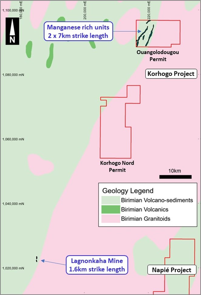
Korhogo Nord Permit and Ouangolodougou Permit
Manganese Discovery
Mako Gold recently announced a significant manganese discovery which has the potential to be a globally significant deposit and provides Mako with an entry into the critical battery minerals race.
The reconnaissance 10-hole RC drill program tested for subsurface manganese mineralisation on two parallel manganese-rich lithological units, each of which are over 7km in strike length for a combined total exceeding 14km.
The average spacing of the individual drill holes is over 1km and has literally only “scratched the surface”. Initial field mapping and drilling indicates that the mineralised zone could be much more extensive, and very likely much deeper. Further drilling is warranted to test the full width and greater depth of the prospect.
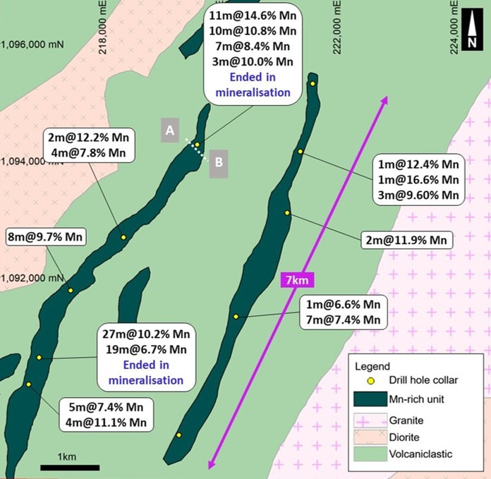
Ouangolodougou Permit with reconnaissance drill hole location and results.
There is only one drill hole at each location and that average drill hole spacing is over 1km apart.
Wide Manganese Intercepts
Several holes confirmed multiple wide manganese intersects at shallow depth. An enlarged map of drill hole OURC003 is shown below, showing multiple wide manganese intersects. Portions of the hole remain to be analysed, pending results of testing of pulverised lab pulps with a portable XRF instrument by Mako. This hole also ended in mineralisation at 50 metres, again proving the potential for depth extension of the mineralisation.
Only 25m of the 260m width of the Mn enriched zone was tested, again showing the potential of significant widths of the deposit. Results for this hole are:
- 11m at 14.6% Mn from surface; and
- 10m at 10.8% Mn from 15m;
- 7m at 8.4% Mn from 36m;
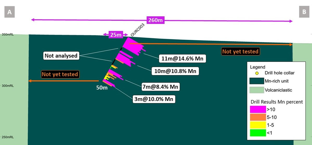
Cross section of OURC003 - 31m of the 50m hole intersected manganese with some intervals not yet analysed - Note the 260m width which is largely untested.
The phosphorous content of the drill samples is low. Phosphorus is a harmful element for most types of steel and the steelmaking process has strict requirements on the phosphorus content of raw materials. The low phosphorous content in the drill samples is encouraging for potential DSO for the steel market.
Manganese Mining in Côte d’Ivoire
Côte d’Ivoire is a top 10 global producer of manganese with 36,000MT of Mn produced in 2022.[1] Ore is shipped from the manganese mines by truck to the port(s) in the south of Côte d’Ivoire where it is then stockpiled before being loaded onto ships for export to China.
[1]Refer to Investment News Network article dated 25 April 2023

Manganese ore stockpiles waiting to be loaded onto ships at the port of San Pedro, Côte d’Ivoire – recent photo by Mako Director.
There are four manganese mines in Côte d’Ivoire operated by private unlisted companies. The mine closest to Korhogo is the Lagnonkaha Mine situated 70km along strike to the southwest of Mako’s manganese discovery in the same lithological unit. The total strike extent of the Lagnonkaha Mine is 1.6 km.
The extent of the potential strike on Mako’s permit is interpreted as more significant given Mako’s two parallel manganese-rich units have a combined strike length of 14km, indicating the potential for a world class manganese resource.
The extent of the potential strike on Mako’s permit is interpreted as more significant given Mako’s two parallel manganese-rich units have a combined strike length of 14km, indicating the potential for a world class manganese resource.
Next steps
- Detailed geological mapping and rock-chip sampling - A detailed mapping and rock-chip sampling program is planned shortly after the completion of the diamond drilling program at the Napié Project. The previous mapping/rock chip sampling program was preliminary in nature and completed in under 4 days with one crew. Several teams of Mako geologists will systematically map and sample the twin 7km Mn-rich zones over approximately three weeks. The result will be a detailed geology map which will highlight the higher-grade areas for follow-up work. Once results are received from the rock chip sampling, the highest priority areas will be selected for a ground geophysical survey.
- Ground geophysical survey - An induced polarisation (IP) geophysical program will commence shortly after receipt of the rock chip sample results. The survey will be conducted over a 1km strike area identified by the mapping/ rock chip sampling program. The IP results should clearly outline the manganese deposit at depths up to 100m, highlight the higher-grade areas, and, importantly, identify the width and dip direction of the deposit for future drilling.
- Metallurgical testing – A consultant has been chosen to complete preliminary metallurgical testing on a 160kg sample of manganese rock. It is anticipated that this will follow the results of mapping/rock chip sampling program and IP survey once the best area to sample is determined. A sequence of tests would prioritise economic recoveries of coarse manganese at saleable grade for steel production with relatively simple flowsheet options.
- Future drilling - A wide-spaced diamond drilling and RC drilling program will be planned following the completion of the above work.